Exercise 4: Species data to raster
Download data
If you haven’t yet done so, download the source data for the arcpy-exercise from this link
GitHub-repo
If you wish, you can document your work into GitHub: FEC2017-Exercise4-arcpy
Overview
The goal of this exercise is to develop a tool for separating the source data (one shapefile containing species distributions of several different subspecies) into separate rasters for each species.
As an output of this exercise we will create two ArcPy-scripts:
- Version 1: Arcpy_1_SimplePoly2Raster.py
- Version 2: Arcpy_2_SpeciesPoly2Raster_Iterate.py
We will write the scripts together in the class, but if you wish you can also proceed at your own pace by following the instructions in the upcoming sections. Feel free to document your codes into GitHub.
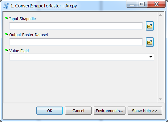
Species data tool: Version 1
Create a ArcGIS toolbox that converts a Shapefile into a Raster Dataset.
Toolbox asks three parameters from the user: input shapefile, output rasterdataset, and value field (raster_value).
Toolbox executes a python script called Arcpy_1_SimplePoly2Raster.py that contains all the required functionalities of the tool.
Required steps in the script-file for Version 1:
- Import the required module (arcpy)
- Get parameters from the toolbox using
GetParametersAsTextfunction - Convert input shapefile into a Raster Dataset using PolygonToRaster_conversion -function
- Print info for the user that tool has finished successfully using
AddMessagefunction
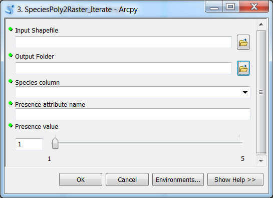
Species data tool: Version 2
Create a ArcGIS toolbox that converts individual species in a Shapefile into Raster Datasets based on species information on attribute field binomial. Tool asks five parameters: input shapefile, output folder, species_attribute, attribute_name_for_raster_value, raster_value. Tool will print useful information for the user about the execution process. Toolbox executes a python script called Arcpy_2_SpeciesPoly2Raster_Iterate.py that contains all the required functionality of the tool.
Required steps in the script-file for Version 2:
- Import the required module (arcpy)
- Get parameters from the toolbox using
GetParametersAsTextfunction - Add a new field into the Shapefile with
AddField_managementfunction - Update the value for the attribute with
CalculateField_managementfunction - Determine a list of unique species in the Shapefile using
SearchCursorfunction - Create a Feature Layer from the shapefile using
MakeFeatureLayer_managementfunction - Select individual species from the Shapefile using
SelectLayerByAttribute_managementfunction - Convert individual species in the Shapefile into Raster Datasets using
PolygonToRaster_conversionfunction - Print info for the user that tool has finished successfully using
AddMessagefunction
We will start with the simple version 1 in order to illustrate the basic elements of an arcpy-script and how it interacts with a toolbox.